Geo-driven tech is changing disaster response in the Philippines
The Philippines has long endured the wrath of nature—super typhoons, massive earthquakes, and deadly volcanic eruptions have cost thousands of lives and crippled infrastructure. While climate adaptation and disaster response continue to evolve, the absence of scientific hazard data in structural planning leaves many communities dangerously exposed.
To close this critical gap, the Department of Science and Technology (DOST) and PHIVOLCS launched two cutting-edge digital platforms under the GeoRiskPH Initiatives. These platforms—HazardHunterPH and GeoAnalyticsPH—support the PHIVOLCS Modernization Law and bring real-time hazard data directly to the public and local governments.
HazardHunterPH: empowering people through instant hazard data
HazardHunterPH offers free, location-based hazard assessments for earthquakes, volcanic activity, and more. Users can input exact addresses or coordinates and instantly receive risk profiles, safe zones, and AI-powered impact visualizations.
This platform elevates public access to disaster resilience tools and promotes smarter, safer urban development. Its global impact was recognized with a Bronze Award at the 50th International Exhibition of Inventions Geneva (IEIG) in 2025.
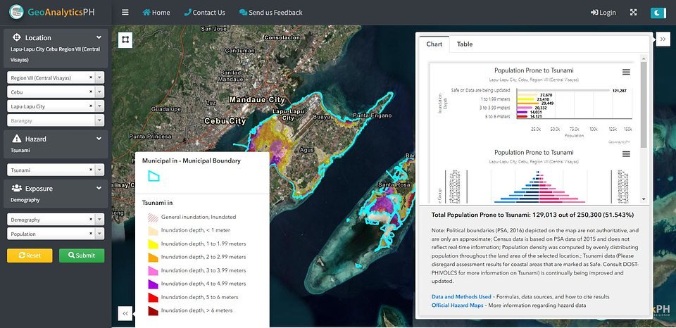
GeoAnalyticsPH: turning risk data into smarter decisions
GeoAnalyticsPH allows local governments and institutions to assess risks by age, sex, population, land exposure, and infrastructure vulnerability. It presents complex data in easy-to-understand visuals like charts, maps, and interactive tables.
From barangays to city planners, this tool empowers even the smallest communities to build science-backed emergency plans. With over 60,000 building footprints digitized, the Philippines is taking a major step toward nationwide disaster resilience.